Cutalong Marina Required Back of Contrary Creek Dredging
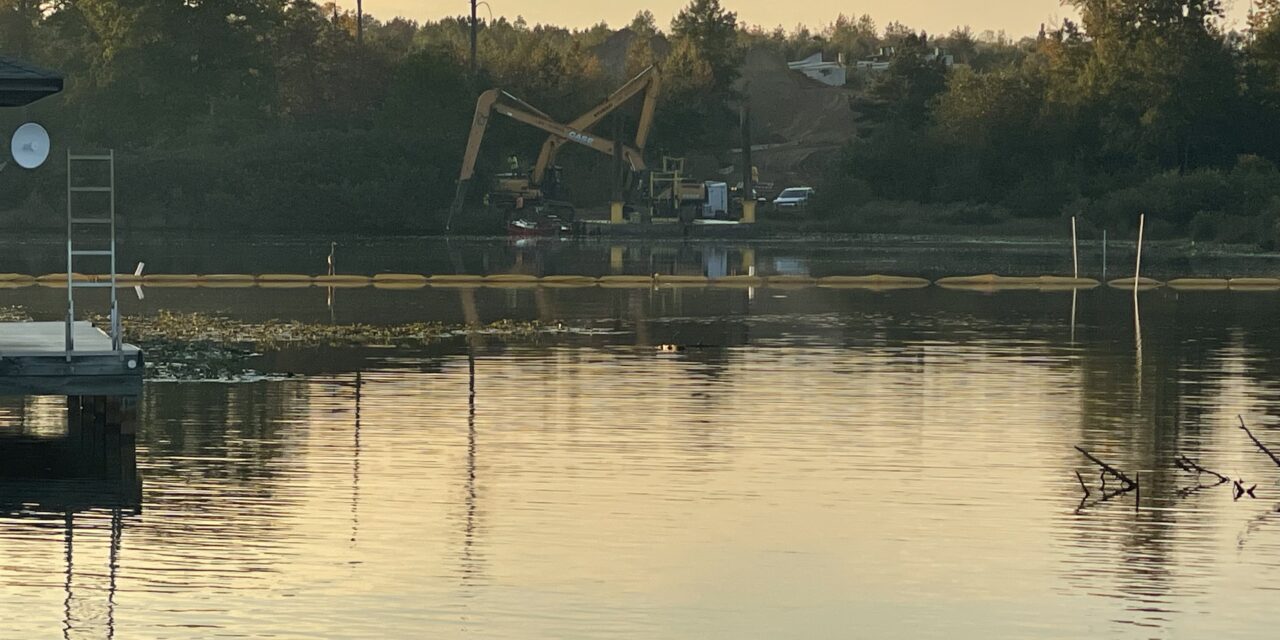
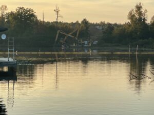
Residents of the Freshwater and Shorewood subdivisions in the back of Contrary Creek discovered one morning last month that a major dredging effort was underway as part of the Cutalong golf community.
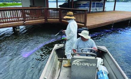
Vanasse Hangen Brustlin, Inc. or VHB staff operated two amphibious dredges for the next 15 days to remove approximately 79,000 sq. ft./3,437 cu. yds. of soil under the water in the back of Contrary Creek to prepare the area for the construction of boat slips and a private marina for the community.
The Virginia Department of Environmental Quality monitored the dredging as the substrate below the water was known to contain heavy metals left over from extensive mining operations above the dredging site.
VDEQ’s Water Quality Monitoring Plan (WQMP) for the marina project at Cutalong at Lake Anna was designed to gather information to assess potential impacts on water quality during the execution of this work. The objectives of the monitoring program were to:
• Evaluate potential impacts on water quality caused by dredging;
• Help the contractor ensure compliance with water quality criteria (WQC);
• Provide information to evaluate the effectiveness of operational controls to achieve compliance with WQC during dredging; and
• Document the monitoring activities and sampling results in a final report.
This WQMP also provides additional information, including:
• Field procedures and schedule for implementing the WQMP;
• Responses to address contingency measures that might be used if WQC are exceeded; and
• Requirements for the timing and reporting of monitoring program results.
Construction activities were monitored to determine if the work significantly affects surface water quality. For in-water work, monitoring occurred at specific locations within the compliance zone to evaluate compliance with WQC dredged areas and 75 feet downstream of the work areas.
Since a turbidity curtain was utilized to contain suspended sediment, field measurements were collected at designated locations within and outside of the turbidity curtain for total suspended solids and turbidity utilizing a Hach TSS Portable Handheld Turbidity, Suspended Solids and Sludge Level System meter or similar meter. The cable on this type of meter is graduated for easy reproducible depth measurements.
Additionally, per permit requirements, Cadmium (Cd), Copper (Cu), and Zinc (Zn) will be sampled within the water column and analyzed by EPA Method 200.7. These water column samples will be collected with a Kemmerer Sampler at depth, about three (3) feet below the water surface at the sampling stations used for evaluating TSS and turbidity. The Kemmerer Sampler will be deployed open to the depth of sampling, and then a messenger will be sent down the line to trigger the sampler to close, thereby collecting a discrete sample at depth.
Results of the metals analyses will be compared to baseline data collected prior to dredging along with DEQ Surface Water Standards.
The point of compliance where the WQC must be met for water column monitoring during in-water work is a maximum distance of 75 feet from the point of disturbance or work activity that may create turbidity.
Results of the VDEQ monitoring have not yet been made available.
3.3 Monitoring Schedule
Since the anticipated dredge activities will be done over a two (2) week period, monitoring of turbidity and total suspended solids will be done on a daily basis and the metal analyses will be done every three (3) days upon commencement of the dredging. Collection of data related to turbidity and TSS, along with the three (3) metals will be done the week prior to construction activity to establish a current baseline of these parameters. Additionally, sample collection will continue after the construction activities are completed to evaluate the affects, if any on the water column and surrounding area for these parameters. Sampling of the water column will be done one (1) week after completion and at five (5) of the previous water sampling locations selected by VHB and Meridian. This single sampling event will be considered the ”Closure Sampling Event”.
The daily data collected pertaining to TSS and turbidity will be evaluated for exceedances over the baseline data collected prior to the construction and any significant exceedances of greater than 20% will trigger an adjustment dredging activities if there are exceedances.
3.4 Monitoring Locations
Representative in-water monitoring locations are shown on Plan Sheet C2 . These locations are strategic in location to evaluate the water column for TSS, turbidity, Cd, Cu, and Zn based on the construction activities related to the dredging. The thirteen (13) locations selected will be stationary points marked with 1” threaded PVC pipe with a push point on the end that will allow for consistent spot measurements of TSS and turbidity, along with collection of the discrete samples for the metals.
As stipulated in the permit, the sample locations are 75 feet from the construction activities, but since a turbidity curtain will be part of the mitigation protocols, collection of water quality parameters will be not only at this downstream distance, but also within the turbidity curtain as depicted on Sheet C2.
Additional monitoring may be conducted in or near the project at the discretion of the VHB and Meridian directing the field effort. The intent is to adapt monitoring to field conditions and address concerns about dredging or conditions that may affect water quality near the dredging activities. Details about the type and frequency of additional monitoring and the location and rationale for performing it will be documented in the field logbook.
Monitoring depth at the sample and background locations will be one vertical monitoring point set in the middle of the water column, since normal pool level of Lake Anna is 250 feet msl and final dredge elevation will be 244 feet msl.
3.5 Water Quality Criteria Measurement and Equipment
3.5.1 TSS and Turbidity Measurement Methodology
WQC will be measured three (3) times a day in the water column using a subsurface TSS/turbidity sensor attached to a Hach TSS Portable Handheld Turbidity, Suspended Solids and Sludge Level System meter or similar deployed about three (3) feet the water surface. The data from the meter will be documented in field book that will include station location, time and date, along with weather conditions for the day.
The daily measurements collected three (3) times a day for TSS and turbidity measurements will be logged and recorded to determine whether there is an exceedance when compared with corresponding data from the background location data previously collected prior to commencement of the dredging. Collection of water samples for off-site laboratory analysis of TSS and turbidity will not be required.
3.5.2 Monitoring Location Measurement and Documentation
Distances from the monitoring locations will be verified through differential global positioning system (DGPS) readings or by an accurate ranging device, such as a laser rangefinder. If DGPS methods are used, one reading will be needed at a fixed location, and then a second reading will be needed at the proposed monitoring location. Actual DGPS coordinates, times, and depths of all monitoring locations will be recorded. DGPS accuracy will be ±6 feet.
3.5.3 Water Quality Exceedance at Monitoring Station
If turbidity is measured greater than 10 NTU above background at the monitoring station, the following sequence of responses will be initiated:
The field personnel will wait 5 to 10 minutes and take a confirmation measurement at the station.
1. If the confirmation measurement does not confirm exceedance of water quality criterion (10 NTU above background), the monitoring crew will resume the scheduled monitoring activities. 2. If the exceedance is confirmed, the field lead will visually assess the station vicinity for potential outside influences, such as storm drains or sediment disturbance from nearby vessels. i. If outside influences are observed, the field lead will inform the owner’s representative. Additional discretionary measurements may be taken to understand the nature of the outside influence.
ii. If the elevated measurement is attributed to construction activities, the field lead will contact the owner’s representative. The owner’s representative will notify the contractor, and the contractor will modify its work activity using BMPs to reduce water quality impacts.
iii. The field lead will retake measurements within 30 minutes to 1 hour of the initial exceedance at the monitoring station. Additional confirmation measurements will be taken every 2 hours until compliance is met or it gets dark, whichever occurs first.
In addition, the observation of a turbidity plume at the monitoring station will trigger monitoring of the plume.
3.5.4 Monitoring Equipment Calibration and Handling
The TSS and Turbidity monitoring equipment will be calibrated before use for the monitoring program. If the instrument manual calls for more frequent calibration for the types of measurements being made and the conditions, the calibration frequency will conform to the specifications in the manual.
Calibration information will be recorded and calibration records maintained. The monitoring sensors will be allowed to equilibrate before logging measurements. Monitoring equipment will be handled according to manufacturer’s recommendations. Unusual or questionable readings will be noted and addressed appropriately.
3.5.5 Documentation
The TSS and turbidity measurements from the monitoring equipment will be logged and recorded three (3) times a day. When pertinent, additional information regarding monitoring locations, weather conditions, visual observations at the monitoring locations and vicinity of construction activities, and the presence or movement of watercraft (generally, all information that might be pertinent to water quality) will be recorded on a field data sheet and saved in the field notebook. If necessary, a standard site map showing the general work area will be used for noting monitoring locations and sketching any features or conditions that might influence water quality near the monitoring locations.
The following quality control data will be collected and recorded:
• Names and affiliations of technical and support staff;
• Monitoring locations and times for all measurements;
• Depth measurements; and
• Calibration data for field equipment.
SECTION 4 – RESPONSE TO EXCEEDANCES OF WATER QUALITY CRITERIA
VHB and Meridian will monitor the TSS and turbidity data for WQC exceedances. The TSS and turbidity will be evaluated for when there are WQC exceedances. When there are exceedances, VHB and Meridian will take steps to confirm the exceedance and then take appropriate corrective actions with the dredge contractor. The following information will be collected:
• A description of the nature and cause of noncompliance, including the quantity and quality of any unauthorized discharges and the measurement of confirmed exceedances;
• The period of noncompliance, including exact dates, duration, times, and the anticipated time when compliance will be reestablished; and
• The steps taken, or to be taken, to reduce, eliminate, and prevent the recurrence of the non compliance.
VHB and Meridian will require contractors to take all appropriate corrective actions if WQC exceedances are confirmed. Corrective actions may include implementation of additional best management practices (BMPs) or modification of work methods and operations. For in-water operations, corrective actions may include the following:
• Confirming that the monitoring equipment is working properly, performing equipment cleaning, and recalibration, as necessary;
• Increasing dredging cycle time (a longer time reduces the velocity of the ascending/descending bucket through the water column, which reduces potential wash sediment from the bucket and suspend sediment as the bucket contacts the sediment surface);
• Checking for conformance with BMPs for dredging (no bottom stockpiling, no multiple bites, no dragging the dredge bucket, proper performance of the dredge equipment, etc.); and
• Checking for and removing debris that may be interfering with in-water operations.


