AWS Data Center Coming To Lake Anna
By Tammy Purcell/Engage Louisa
Amazon Web Services has submitted a Joint Permit Application to the Army Corps of Engineers and the Virginia Department of Environmental Quality that reveals more details about the tech giant’s plan to invest $11 billion to build data centers in Louisa County.
AWS and REB Investment Company, LLC filed the JPA on September 1, requesting permission to build a data center campus on 153 acres at the corner of Kentucky Springs Road and Haley Drive adjacent to the North Anna Nuclear Power Station. AWS intends to develop the campus over the next 15 years, according to the application. REB Investment Company is the parcel’s current owner. The COE and DEQ permits are required because the project would permanently impact jurisdictional wetlands and other waters of the US (WOTUS).
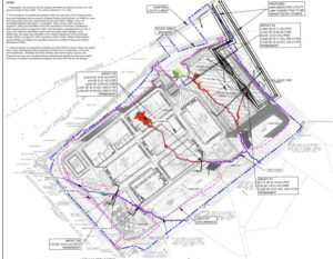
According to a conceptual plan included in the application, AWS intends to build seven standard data centers on the property—dubbed the Lake Anna Tech Campus (LATC)—covering some 1.7 million square feet and providing a minimum of 420 megawatt (MW) of data center capacity “to serve the expanding demand for cloud-based computing.” The campus is also expected to include an administration building, two smaller buildings, described in the application as “specialty data centers,” two substations capable of providing 300 MW of power each, stormwater basins, a rainwater harvesting pond and water and sewer infrastructure.
Of the seven standard data centers, five are expected to reach 74 feet tall and include 256,284 square feet of floor space across two stories. A sixth two-story building would also reach 74 feet high and encompass about 185,000 square feet. The seventh building would be one story and cover 151,895 square feet. A 65,000-square foot, two-story administration building and adjoining parking would sit at the entrance to the property near the corner of Kentucky Springs Road and Haley Drive. The two other buildings, one-story structures measuring about 14,000 square feet each, and the dual substations would sit near the rear of the property.
The water and sewer infrastructure featured in the plan includes a septic system, water treatment facility and above-ground water storage tanks. Per information previously shared by Louisa County, the campus is expected to draw raw water from the county-owned Northeast Creek Reservoir in central Louisa with AWS footing the bill for a water line to the site. But the application, prepared by Wetland Studies and Solutions, suggests that the campus could rely on groundwater and rainwater harvesting.
“The Lake Anna Tech Campus will require water to operate and provide cooling for the data center buildings. This site has no direct access to a water line, however, has undergone various geotechnical studies and has determined there is enough groundwater and rainwater that can be captured to support their needs,” the application states.
The conceptual plan offers only a preliminary look at AWS’s plan for the site. The application states that the plan could change as long as those changes don’t alter the scope or nature of the project’s impact on wetlands and waterways.
The project would permanently impact 1.5 acres of wetlands and WOTUS including 1,538 linear feet of perennial stream channel, per the application. The impact would result from “the filling and grading necessary for construction of the substation pads, data center buildings, as well as interior access roads and other related infrastructure.” As required under the federal Clean Water Act, AWS proposes to mitigate the project’s impact by purchasing wetland mitigation credits from an approved mitigation bank or from the Virginia Aquatic Resources Trust Fund.
In late August, Louisa County announced that AWS plans to invest $11 billion to build two data center campuses in its newly created Technology Overlay District, a special zoning designation approved by the Board of Supervisors in April that’s designed to attract lucrative tech sector industry. One of the campuses in slated for the Kentucky Springs Road parcel while the other—the North Creek Tech Campus—is planned for 1,400 acres south of Route 33 across from the Northeast Creek Reservoir.
Together, the campuses would include 11 data centers, according to Louisa County Economic Development Director Andy Wade. While the project isn’t expected to reach full buildout until 2040, Wade said AWS could have at least one data center up and running at the Lake Anna site by 2025. The JPA states that AWS has a “contractual obligation” to begin construction at the LATC by April 2024.
A narrative included in the application describes the LATC as a critical piece of AWS’s long-range plan to increase data center capacity between Northern Virginia and Richmond.
“This project is a critical part of the Applicant’s overall operating and strategic plan whose goal is to bridge the gap for the Applicant between the Northern Virginia and Richmond markets to provide availability zones (AZs) in this area. Additionally, part of the applicant’s goal is to have data center campuses in each County between Northern Virginia and Richmond, and as such the Lake Anna Tech Campus is part of their Louisa County initiative,” the application states.
The Lake Anna site has sparked concern among some in the community, including representatives of the Louisa County Historical Society (LCHS), who’ve cited the parcel’s historical significance. The property was once part of a plantation and is home to the ruins of Laurel Hill, a circa 1800 home that was owned and occupied by the Garland sisters. After the Civil War, the sisters gained notoriety for their work with the Freedmen’s Bureau to reunite Black families torn apart by slavery. The sisters donated land and money to formerly enslaved people, leading to the establishment of Garlandtown, a once prominent Black community in eastern Louisa County.
LCHS staff have also raised concerns about potential gravesites on the property. To make way for Lake Anna in the early 1970s, the remains of at least 100 residents were excavated and reinterred at Laurel Hill Baptist Church, a historic Black church that adjoins the project site to the southeast. Brianna Patten, outreach coordinator for the society’s African American History Program, said in an email in mid-September that it’s unclear how many graves were moved to the church’s property based on records from the time and whether they cross over the property’s shared boundary with the data center site. Patten also said that it was “common for the cemeteries of enslaved people to be placed in unmarked locations on plantations.”
As part of the Joint Permit Application, R. Christopher Goodwin & Associates conducted a Phase I archeological assessment on the property and a Phase II evaluation on a portion of the site around the ruins of Laurel Hill. Neither study mentions the presence of graves. But, according to the Phase II evaluation, the house site could be eligible for inclusion on the National Register of Historic Places because of its connection to the sisters and antebellum history.
Given its historical significance and because the applicant says the house site can’t be avoided in the project’s development, the archeologists recommend undertaking “Phase III archeological data recovery” to mitigate adverse effects. A Phase III data recovery generally refers to extensive archeological investigation including excavation, testing, mapping and analysis of materials found at the site. The application doesn’t include any details of Phase III work.